World War One Sites - The NETWORLD Database
Austro-Hungarian Military cemetery Kreuztratte, Plöckenpass, Carinthia, Austria
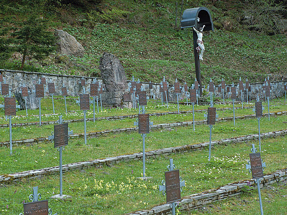
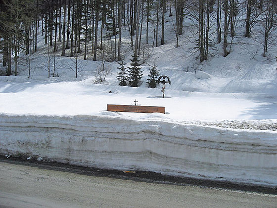
The Kreuztratte military cemetery is located at around 1,000 metres above sea level along Plöckenstraße. 591 war dead are buried here. The cemetery was established by the Austro-Hungarian troops immediately behind the front line and was heavily damaged as a result of bad weather, avalanches and metre-high snow. The cemetery was refurbished several years ago.
Austria, Kärnten
Type of WWI-heritage
- Military cemetery
Dimensions
The Kreuztratte military cemetery is located at around 1,000 metres above sea level along Plöckenstraße.
State of repair/preservation
The military cemetery is in good condition and is supervised by the Austrian Black Cross.
Historical WWI Context
The Kreuztratte military cemetery is located in the Carnic Alps that formed a section of the so-called Southwestern Front – this was the front dividing Austria-Hungary and Italy from May 1915 onwards. A total of ten military cemeteries are found in the complete section of the Carnic front. Those in the Angerbachtal and Valentinbachtal were set up by Austro-Hungarian troops especially near to the front. As well as military cemeteries in the Plöcken region, other cemetery facilities are found in the Gailtal and Lesachtal (Maria Luggau in the Lesachtal, St. Lorenzen in the Lesachtal, Liesing in the Lesachtal, Birnbaum in the Lesachtal, Mauthen, Griminitzen, Dellach in the Gailtal, Rattendorf, Tröpolach, Nassfeldkapelle and Thörl-Maglern). The Southwestern Front stretched over a length of around 600 kilometres in a linear distance from the Swiss border to the Adriatic coast. Italian, Austro-Hungarian and German soldiers mainly faced each other on this part of the front between 1915 and 1918, primarily in high-Alpine terrain and usually at an altitude of 2,000 to 3,900 metres above sea level. In 1915, soldiers on both sides initially had to make the complete terrain suitable for military operations. Apart from a few mountains made accessible for tourists and trails used by the indigenous population in summer for cattle driving, hardly any well-developed paths or tracks existed between the Ortler (3,899 m) near to the Swiss border and the Julian Alps. In the Plöcken region the Frischenkofel/Cellon (2,238 m) had major military importance for the Austro-Hungarian and Italian troops because of the Plöckenpass/Passo di Mt. Croce Carnico (1,357 m) and because of the Austro-Hungarian Plöcken blockade at this location. In the early summer of 1915 it was occupied alternately by the Italian and Austrian-Hungarian troops during the course of several operations. Italian troops then finally brought themselves into position. Austria-Hungarian troops on the other hand positioned themselves on the Cellon shoulder. |
Kleiner Pal, initially occupied by Italian troops, should have been taken over in June 1915 by around 400 soldiers of the Austro-Hungarian army. However, military success for both sides was in the end moderate because the Italian and Austrian-Hungarian troops were separated from each other by just a few metres in the summit region of Kleiner Pal. As a consequence, both sides expanded their trenches on Kleiner Pal: they constructed caverns, galleries and tunnel systems in the summit area as well as cable systems and tracks across the front to ensure replenishments from the valley.
Recent Images
Historical Images
State of legal protection
The area is not under protection.
Owner
Kind of cultural use of WWI
The “Open-Air Museum of the Mountain War 1915–1917” on the Plöckenpass can be visited for free. |
Opening
“Museum 1915–18. From the Ortler to the Adriatic Coast”, Kötschach-Mauthen Season runs from 15 May – 15 October Visits by groups are also possible with appropriate pre-registration outside of opening times. For further informatin see: www.dolomitenfreunde.at |
Entrance Fee
The “Freilichtmuseum des Gebirgskrieges 1915–1917” [Open-Air Museum of the Mountain War 1915–1917] consists of various parts that are located in close proximity. The sectors are not bordered or fenced off. Entry is free and is at the visitor's own risk.
Information regarding cities, villages, other touristic attractions (non-WWI) nearby
Further information: |
Accomodation
Further information: |
Public Transport
The region around Kötschach-Mauthen is well-connected to the public traffic network (buses).
Further information:
ÖBB: www.oebb.at
Further information sources
Publications:
Österreichisches Schwarzes Kreuz (Hg.), Kriegsgräberfürsorge. Dokumentation, Wien (2012).
Gabriele & Walther Schaumann, Unterwegs vom Pustertal zum Plöckenpass. Auf den Spuren der Karnischen Front 1915–1917, Klagenfurt (2003).
Gabriele & Walther Schaumann, Unterwegs vom Plöckenpass zum Kanaltal. Auf den Spuren der Karnischen Front 1915–1917, Klagenfurt (2004).
Gabriele & Walther Schaumann, Unterwegs zwischen Save und Soča. Auf den Spuren der Isonzofront 1915–1917, Klagenfurt (2005).
Julia Walleczek-Fritz & Peter Fritz, Begehen-Begreifen-Bewahren. Der Erste Weltkrieg entlang des Karnischen Kamms zwischen Sexten und Plöckenpass, Kartitsch/Sexten (2015).
[English Version: Julia Walleczek-Fritz & Peter Fritz, Ascend-Apprehend-Aspire. The First World War along Carnic Ridge between Sexten and Plöckenpass, Kartitsch/Sexten (2015).]
Ludwig Wiedemayr, Weltkriegsschauplatz Osttirol. Die Gemeinden an der Karnischen Front im östlichen Pustertal, Lienz (2007).
Other heritage sites nearby
Museums Private Collections
Further information: www.dolomitenfreunde.at
Austro-Hungarian Military cemetery Kreuztratte, Plöckenpass, Carinthia, Austria
46.622991479784886 12.946866948352521 fileadmin/res/images/layout/standar-marker.pngLocation

