World War One Sites - The NETWORLD Database
Austro-Hungarian Military cemetery Hochgränten, East Tyrol, Austria
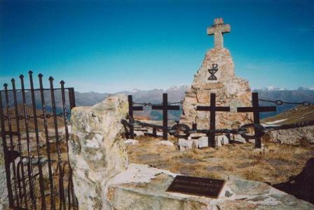
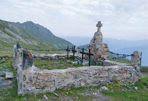
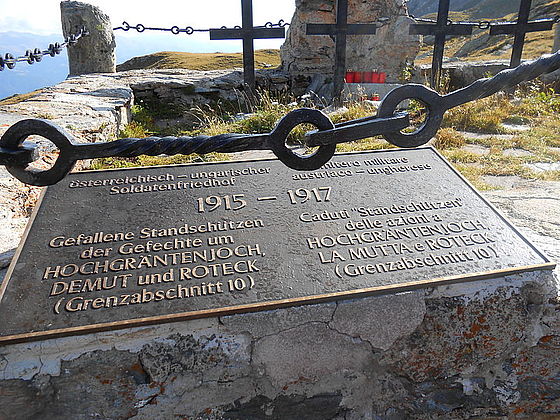
The Hochgränten military cemetery was laid in 1915 by Austro-Hungarian soldiers. It contains the graves of four riflemen who lost their lives on 6 September 1915 on the ridge between the Hochgränten Joch and the Hollbrucker Spitz. The graves are decorated by wrought iron crosses and an obelisk with a cross and inscribed panel. The cemetery itself is surrounded by a stone wall with wrought iron chains and lattice doors.
Austria, East-Tyrol
Type of WWI-heritage
- Military cemetery
Dimensions
The Austro-Hungarian military cemetery Hochgränten (2,429 m) in the Carnic Alps (Karnischer Kamm, borough of Kartitsch, cadastral commune of Hollbruck) consists of an area of approximately 4 x 3 metres. The cemetery is the highest-situated military graveyard in the eastern Alps.
State of repair/preservation
The Hochgränten military cemetery is in relatively good condition and is maintained by the Austrian Black Cross as part of the War Graves Commission.
Historical WWI Context
The Hochgränten military cemetery is situated near the Hochgräntenjoch on Karnischer Kamm (Carnic Ridge). Near to the Hochgränten Lake in this region, Austro-Hungarian troops established this military cemetery in 1915 in which soldiers are buried who lost their lives during the battles in this sector. The cemetery still contains the graves of four riflemen.
The Karnischer Kamm formed a section of the so-called Southwestern Front – the front situated between Austria-Hungary and Italy from May 1915 onwards. It stretched over a length of around 600 kilometres in a linear distance from the Swiss border to the Adriatic coast. Italian, Austro-Hungarian and German soldiers faced each other on this part of the front mainly between 1915 and 1918, primarily in high-Alpine terrain and usually at an altitude of 2,000 to 3,900 metres above sea level. In 1915, soldiers on both sides initially had to make the complete terrain suitable for military operations. Apart from a few mountains made accessible for tourists and trails used by the local population in summer for cattle driving, hardly any well-developed paths or tracks existed between the Ortler (3,899 m) near to the Swiss border and the Julian Alps.
To enable Austria-Hungary to control the region of the front, the area was subdivided by their army into several administration units. Border sector 10 for example consisted of several border sub-sectors (GUA), and these in turn consisted of battle sectors (KA): GUA 10a consisted of the battle sectors Ruffredo, Gemärk and Landro (later called Schluderbach), GUA 10b of battle sectors Zinnenhochfläche, Fischleintal, Burgstall and Hornischeck/Hornischegg (known as “Seikofel” from 23 June 1915), and GUA 10c of the battle sectors Eisenreich and Filmoorhöhe. While border sub-sector 10a continued to be under the command of Field Marshal Lieutenant Ludwig Goiginger, the two border sub-sectors 10b and 10c came under the responsibility of the 56th Mountain Brigade from November 1915 and the command of General Major Karl Englert.
The front on the Karnischer Kamm belonged to border sub-sector 10c, had a length of approximately 30 kilometres and stretched from Hornischegg/Mt. Arnese (2,550 m) to Steinkarspitz/Mt. Antola (2,524 m) in the East. From 1916 onwards, border sub-sector 10c was administrated as a border sector and subdivided into battle sectors I: Hochgränten, II: Obstans, III: Filmoor/Leiten and IV: Obertilliach. The most northerly area of the Kreuzberg front was integrated into battle sector I: Hochgränten. From October 1916 the official name of border sub-sector 10c became “Karnischer Kamm”.
Recent Images


Historical Images
State of legal protection
The Hochgränten military cemetery is heritage-protected.
Owner
No information available.
Kind of cultural use of WWI
The Hochgränten military cemetery can be visited for free and is situated on the long-distance hiking route Karnischer Höhenweg (no. 403), also called the Trail of Peace ("Via della Pace"). The trails of peace were set up by the Austrian Dolomitenfreunde association in the 1970s.
Further information:
www.karnischer-hoehenweg.at
The “Open-Air Museum of the Mountain War 1915–1917” on the Plöckenpass can be visited for free.
Further information:
www.dolomitenfreunde.at
Entry must be paid to the “Museum 1915–18. From the Ortler to the Adriatic Coast” in Kötschach-Mauthen that focuses on the history of World War One in the mountains.
Opening
The Hochgränten military cemetery can be visited for free.
The “Museum 1915–18. Vom Ortler bis zur Adria” (From the Ortler to the Adriatic Coast), Kötschach-Mauthen
Season runs from 15 May – 15 October
Opening times during the season:
Monday to Friday 10am–1pm and 3pm–6pm
Saturday, Sunday and bank holidays 2pm–6pm
Visits by groups are also possible with appropriate pre-registration outside of opening times.
Further information:
www.dolomitenfreunde.at
Entrance Fee
The Hochgränten military cemetery can be visited for free.
Information regarding cities, villages, other touristic attractions (non-WWI) nearby
Further information:
Region Karnische Alpen: www.karnische-alpen.com
Mountain climber villages: www.bergsteigerdoerfer.at
Lesachtal: www.lesachtal.com
City of Lienz: www.lienz.gv.at
City of Spittal at Millstättersee: http://www.millstaettersee.com/de/region-orte/spittal-drau/spittal-drau.html
Accomodation
Further information:
Lesachtal: www.lesachtal.com
Mountain climber villages: www.bergsteigerdoerfer.at
Region Karnische Alpen: www.karnische-alpen.com
Public Transport
The public traffic network (trains and buses) connects the communities in Lesachtal along Karnischer Kamm with the towns of Lienz in the West and Spittal in the East.
Further information:
ÖBB: www.oebb.at
Further information sources
Publications:
Österreichisches Schwarzes Kreuz (Hg.), Kriegsgräberfürsorge. Dokumentation, Wien (2012).
Gabriele & Walther Schaumann, Unterwegs vom Pustertal zum Plöckenpass. Auf den Spuren der Karnischen Front 1915–1917, Klagenfurt (2003).
Gabriele & Walther Schaumann, Unterwegs vom Plöckenpass zum Kanaltal. Auf den Spuren der Karnischen Front 1915–1917, Klagenfurt (2004).
Gabriele & Walther Schaumann, Unterwegs zwischen Save und Soča. Auf den Spuren der Isonzofront 1915–1917, Klagenfurt (2005).
Christian Terzer, Frontstellungen im Hochgebirge. Das Projekt Karnischer Kamm, in: Österreichische Zeitschrift für Kunst und Denkmalpflege, Ort - Erinnerung - Denkmal. Relikte des Ersten Weltkriegs, Heft 3/4 (2015), S. 262–271.
Julia Walleczek-Fritz & Peter Fritz: Ascend-Apprehend-Aspire. The First World War along Carnic Ridge between Sexten and Plöckenpass, Kartitsch/Sexten (2015).
Ludwig Wiedemayr, Weltkriegsschauplatz Osttirol. Die Gemeinden an der Karnischen Front im östlichen Pustertal, Lienz (2007).
Other heritage sites nearby
- Trail of Peace / Karnischer Höhenweg in the Carnic Alps, East Tyrol and Carinthia, Austria
- Prinz-Heinrich Memorial chapel, East Tyrol, Austria
- Open-Air Museum of the Mountain War 1915–1917, Plöckenpass, Carinthia, Austria
- Austro-Hungarian Military cemetery Kreuztratte, Plöckenpass, Carinthia, Austria
- Chapel of Peace at Zollnersee, Carinthia, Austria
- Outdoor Museum Ravelnik, Bovec, Slovenia
- Austro-Hungarian Military Cemetery Log pod Mangartom, Slovenia
Museums Private Collections
“Museum 1915–18. Vom Ortler bis zur Adria” ( (From the Ortler to the Adriatic Coast), Kötschach-Mauthen (Carinthia)
Further information:
www.dolomitenfreunde.at
Austro-Hungarian Military cemetery Hochgränten, East Tyrol, Austria
46.69008890065852 12.43976816722568 fileadmin/res/images/layout/standar-marker.pngLocation